
To help us understand and appreciate the wonderful wildlife and habitats found on our seashores the Sussex Wildlife Trust runs a volunteer scheme called Shoresearch.
Find out more and get involved, just visit the Shoresearch page of the Sussex Wildlife Trust
Shoresearch is a volunteer scheme to identify and record animals, plants, and habitats along our shoreline. The aim of the scheme is to build a baseline of data on intertidal wildlife around Sussex, to help promote its conservation.
The Sussex shoreline is almost entirely dominated by fringing shingle. To the east of Hastings sand and shingle are more prevalent. To the west of the County the shingle can form extensive deposits down to low water with our without cobbles and out-crops of rock. Extensive human development occurs along a lot of the coast with the seaside towns such as Bognor Regis, Littlehampton, Worthing, Shoreham-by-Sea, Brighton & Hove, Newhaven, Seaford, Eastbourne, Bexhill and Hastings. From Brighton to Eastbourne chalk cliffs for dramatic backdrops to the coastal scene. Cliff exposures of sandstone occur at Newhaven, Eastbourne, and Hastings to Fairlight. Sub-tidally both chalk and sandstone occur as exposed bedrock and reefs amongst the ‘sea’ of shingle/cobble dominated seabed. Outcrops of clay occur at a number of sites, e.g. Cow Gap near Eastbourne and Fairlight.
The domination of the chalk cliffs has meant much of the Shoresearch work has focused on the wave-cut platforms. At a glance these may appear to be the same from Brighton to Eastbourne, but their structure varies considerably and with it the associated flora and fauna. For example aspect and wave/tide action lead to differences in the form of the gullies which in some areas are quite shallow and easy to walk over, whilst in others the gullies are dangerously deep.
A single visit to a site only provides a temporal snap-shot of what is present. In order to better understand the complex dynamics of the ecology is it is important to visit sites regularly and at different times of the year. Unfortunately the very nature of Sussex Shoresearch means there are severe limitations on site visits, time, tides and the availability of volunteers being key factors in this equation. Despite these difficulties and limitations the data gleaned from the survey work is greatly improving our understanding of the Sussex seashores. Data gathered are inputted into a database that is used nationally: Marine Recorder and these data will be migrated to a national system, as they are for Seasearch. The data can then be used for a variety of purposes including education, research coastal development, conservation etc.
Some links to Sussex Coastal Geology
Old geological map
Brighton & Hove
Beachy Head
West Sussex Geology
Coastal fringe of W. Sussex, Hampshire and the Isle of Wight
Selsey and Bracklesham
Chichester Harbour

Copperas Point, Chichester Harbour; SZ828012
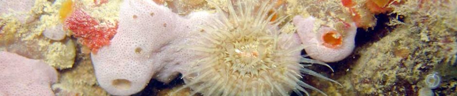
Copperas Point is located on the Fishbourne channel of Chichester Harbour, just to the north of Chichester Marina. Chichester Harbour is an Area of Outstanding Natural Beauty and has national and international designations for the importance of its bird populations and other wildlife. It is also the second largest recreational harbour in the country. There are 10,000 boats in Chichester Harbour and the Marina has 1,000 of these. Copperas Point is an area of very soft mudflats on the lower part of the beach, with a good diversity of saltmarsh plants at the top of the beach. The underlying rocks are London Clay with lumps of copperas (iron pyrites).
Fossils particularly include the small tube-like shells of a worm called Ditrupa plana. Pyritised fossil twigs are common and careful searching may turn up the occasional fossil shark tooth at this site.
Copperas Point was probably a Roman harbour and iron pyrites collected from here has been used for a variety of purposes including dying and smelting throughout the ages.

East Head West Wittering; SZ770981
East Head is the sand dune spit situated at the eastern side of Chichester Harbour. It is a SSSI (site of special scientific interest) and a Ramsar site (a wetland site of international importance).The sand dune spit is about 1000 metres long and 400 metres wide at the widest point and covers about 10 hectares. On the seaward side an extensive area of sand, mud and shingle amounting to about 100 hectares and known as the Winner is exposed at low tide. On the landward side an area of 30 hectares of salt marsh has been formed between East Head and the mainland.

West Beach, Selsey; SZ845929
The fringing shingle leads to sand then exposures of clay containing attached and burrowing life. A wide variety of fossils including Eocene sharks’ teeth and molluscs, can be found in this area.

Selsey, East Beach; SZ867934
The name Selsey is derived from the Saxon Seals-ey and can be interpreted as the Isle of Sea Calves (sea calves are better known as seals). Site consists of a shingle beach with groynes which is good for seahorses and cuttlefish if you are diving.
Site consists of a shingle beach with groynes which is good for seahorses and cuttlefish if you are diving.

Church Norton, Pagham; SZ865966
Image ©Hugh Venables
Pagham Harbour Local Nature Reserve is almost 60 hectares (150 acres) in size. The Reserve is made up of saltmarsh and tidal mudflats with shingle, open water, reed swamp and wet permanent grassland habitats.

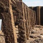
Rock groynes, Elmer; SU990000
Along an otherwise fairly barren shingle-sand shoreline the ‘continental rock groyne’ sea defences provide oases for marine life. The rock groynes run parallel with the shore and thus provide a varied range of habitats, some exposed some hidden.

Bognor Rocks; SZ921984
Exposures of calcareous sandstone in the London Clay occur offshore forming extensive reefs (e.g. Kingmere), these exposures extend into the littoral providing characteristic habitats for a rich and varied range of attached marine life.
Bognor, West Park; SZ921986
This is a typical shingle beach with cobbles and exposures of sand etc. close to the previous site. Much of the stable mid-low shore shingle is vegetated or with animal turf. Some of the cobbles are mobile, carrying their attached weed and life eastwards through the action of strong tidal currents/long-shore drift.

Bognor, East; SZ939988
A fringing area of shingle leads to extensive sand with scattered cobbles some of which are mobile and vegetated with weed, notably Chorda filum; wooden breakwaters present at intervals with the usual life.

Ferring, the Strand; TQ0916401501
The shingle beach to the east of the Blue Bird contains some vegetative shingle. The beach to the west of the Blue Bird has a wide green sward that is heavily used by dog walkers. There is consequently more variety of plants in the shingle.
The plan is to walk out to the submerged village.
Littlehampton, West. beach; TQ 028012 TQ022018
Littlehampton West Beach is part of the Local Nature Reserve (LNR) and the Climping Beach Site of Special Scientific Interest (SSSI), which has national protection. It includes sand flats, shingle, sand dunes. One of only 3 sand dune systems in West Sussex. The eastern boundary of the site is the concrete and wood harbour arm along the eastern side of which flows water from the River Arun.
A visit in May 2014 demonstrated the dynamic state of beaches. Compared with the previous year there was very little to be seen, the winter storms having taken
their toll. There was an absence of algae, apart from some patches of Ceramium and another red with the odd green, Ulva intestinalis, on the sheltered (from the prevailing SW sinds/waves) sides of the legs and N insides of the steel piles. Very few anemones, Actinia equina, present; the dominant and successfully surviving species were Barnacles, Semibalanus balanoides, and Edible Mussels, Mytilus edulis. Limpets, Patella vulgata, were present as were Dogwhelks, Nucella lapillus. The area of exposed shingle on the lower shore was completed denuded - in previous years fucoids and others were present on the larger cobbles. The weed present was torn and tattered fronds of Sea Oak, Halidrys siliquosa, Oar Weed, Laminaria digitata and other algae cast up during the past storms. It was not possible to inspect the infralittoral fringe which is usually a very rich 'seaweed garden'. Here Cat Shark (Dogfish), Scyliorhinus canicula occur; an injured one was found in the shallows at low water.
A Gallery of Images here.

Worthing Pipe; TQ173032
This is an old outflow pipe off the shingle beach that extends offshore. It is colonised by an interesting and varied range of marine life, particularly sponges, hydroids, anemones, sea squirts and seamats.

Widewater, Shoreham; TQ202043
A wide vegetated fringing beach (a local nature reserve) extends through graded shingle and sand down to the low tide level. Near the low water level various burrowing species can be found.
For more information see:
Friends of Shoreham Beach
Management Plan
Exploring Shoreham Beach LNR
Glaucus
Black Rock; Brighton, TQ345029
Brighton Marina forms the western boundary of the beach at Black Rock a special geological site link. a the base of the chalk cliffs runs the undercliff walk and seawall, part of the extensive coastal protection that runs from Brighton to Saltdean. Below this is a series of fringing shingle beaches bounded by sea defence breakwaters. The shingle leads down to a typical chalk wave-cut platform that extends to 70 – 120m.
For further information see Geology

Rottingdean; TQ370020
Rottingdean beach is an area with a fringing shingle beach fronting an intertidal chalk platform, host to a wide range of species that thrive in and among the rocky substrate. On the shingle beach you can also find examples of rare vegetated shingle plants.

Saltdean; TQ380019
At the base of the chalk cliffs runs coastal defences works comprising a seawall and undercliff walk (this extends from the ‘tunnel’ access to the west for 600m and continues to the east to BlackRock Brighton). Below the seawall is fringing shingle beach (which can be reduced to virtually nothing) and chalk platform that is in places is covered at high tide, a feature common to this stretch of coast. This allows a range of algae and other species to thrive on the rocky substrate. Beaches to the east and west have been examined.

Friars Bay, Peacehaven; TV48792
Of all the chalk beaches visited the ones to the east and west of this bay have received the least attention. They comprise fairly deep gullies and owing to the aspects of the shore the form and structure of the gullies varies from west to east.

Newhaven west beach; TV438998
The position and exposed nature of this chalk wave-cut platform provides another example of the varied nature of these types of Sussex beaches. At its extreme end it extends 200m to the low water mark.

Splash Point, Seaford; TV48792
Splash Point is located at the eastern end of Seaford beach beneath Seaford Head. From the top of Seaford Head there are magnificent views across to the Seven Sisters cliffs and also towards Brighton and beyond. Splash Point (just below Seaford Head) can be difficult to reach, as access requires climbing over the coastal protective concrete structures. The shore itself consists of cliffs fringed by shingle with fallen blocks of chalk, leading to a deeply gullied platform. The metal remains of a ship occur on the mid-shore (parts of which extend sublittorally).

Birling Gap; TV555959
Wave-cut platforms to the E and W of the steps have been examined. A fringing shingle beach leads to a strip of exposed chalk bedrock followed by typical gullied chalk wave-cut platform.

Hope Gap; TV505980
Hope Gap is situated at the base of the cliffs between Seaford and Cuckmere Haven. The small cove is only accessible at low tide; this is a unique habitat displaying a wealth of species in the chalk gullies, rockpools etc located there. Surveys have covered beaches to the east, below and to the west of the steps leading to the shore; each of these has its own unique form and associated species. The old D-Day trans-channel communications cable hangs from the cliff and can be found in parts on the wave-cut platform where in places it has made its own gully.

The Seven Sisters VMCA / Cuckmere Haven; TV518977
Also known as the Cuckmere Estuary, this is an area of flood plains in Sussex, England where the river Cuckmere meets the English Channel between Eastbourne and Seaford. The river is an example of a meandering river, and contains several oxbow lakes. The beach at Cuckmere Haven is next to the famous chalk cliffs of the Seven Sisters and is a Voluntary Marine Conservation Area (VMCA). It consists of shingle in the upper shore and a chalk platform with gullies lower down the shore that is covered by high tide. The beach which was commonly used by smugglers in the 16th, 17th and 18th centuries, is now a popular location for tourists with activities including water sports, and country walks.

Cow Gap; TV596957
Cow Gap is located on the Seven Sisters just west of Eastbourne. The chalk grassland on the cliff top is rich in plants and creatures and the beach below the cliffs is unique. Rock pools at the base of these cliffs are full of creatures and plants. The geology in this area is mixed with outcrops of chalk, sandstone and clay (with the ever present fringing shingle) producing quite distinctive substrates for animals and plants.
The Pound, Eastbourne; TV601972
The Pound is located to the western end of Eastbourne’s shingle beach. The rockpools cover 5 ha and at low tide are 0-1m deep. Freshwater springs keep the visibility good and the thin sandstone reef offshore shelters the Pound. The site is enhanced by the shingle specialist plants that grow there. Café, toilets at the far western end of the promenade.
Eastbourne Pier; TV618988
The pier legs provide typical examples of the colonisation of artificial substrates. Their vertical zonation make good examples of ‘vertical beaches’ with the organisms present reflecting the duration of exposure to the tidal cycle and exposure to prevailing winds, tides, currents and the direction of illumination/shading.
Hastings, Rocks; TQ 8293809456

Fairlight Cove / Pett; TQ880120
Fairlight Cove, in the East of the County, exhibits a different habitat to the chalk cliffs and platforms and shingle elsewhere in the County, with sandstone cliffs and a rocky intertidal area.
A gallery of images can be viewed here.
Should you wish to contact me:

Unless otherwise stated all images are Copyright of Gerald Legg, naturaimaging. If you would like to use any images, then high resolution ones can be obtained by contacting me.
This work is licensed under a Creative Commons Attribution-ShareAlike 3.0 Unported License.